
A GPS simplifies navigation. It tracks where you are and where you’ve been. For kayakers, it’s more than a tool—it’s peace of mind. But not all devices handle splashes, sunlight, or long trips.
Choosing the right one means balancing durability, clarity, and battery life. We searched for options built to survive waves, show clear maps in bright light, and last all day. Garmin stands out for rugged designs that fit kayaking’s demands. Also, its accuracy and GPS navigation is heads above the rest of the industry.
This guide focuses on models that keep up with paddling adventures—no frills, just reliable performance where it counts.
Best Of Garmin
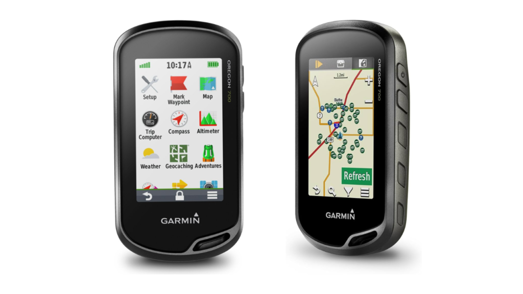
Garmin Oregon 700 Handheld GPS
The Garmin Oregon 700 handheld GPS aims to simplify navigation for fishing trips and outdoor adventures. It balances waypoint tracking, durability, and satellite accuracy. Here’s how it holds up for anglers and kayakers needing reliable tools without unnecessary complexity.
Key Considerations
The Garmin Oregon 700 handheld GPS offers a 3-inch touchscreen that works well in sunlight. Its IPX7 waterproof rating makes it suitable for fishing near water or in rain. The device uses GPS and GLONASS satellites for faster signal pickup, even in dense tree cover or near cliffs.
Storing up to 10,000 waypoints helps anglers mark fishing hotspots. The TracBack feature guides you to your starting point, useful for returning to a boat launch or campsite. However, the Garmin Oregon 700 does not come with detailed maps preloaded. Users often add third-party maps or purchase Garmin’s BlueChart or TOPO maps for water navigation.
Who Is This For
This handheld GPS suits anglers who need reliable waypoint tracking and basic water navigation. It works for kayak fishing or shore fishing where marking spots matters. Hikers and geocachers may also like its rugged design and activity profiles. New users might find the interface overwhelming without online tutorials.
| Pros | Cons |
| Bright, sunlight-readable touchscreen | No detailed maps included |
| Stores 10,000 waypoints for fishing spots | Steep learning curve for settings |
| Waterproof design (IPX7) | Short battery life with alkaline batteries |
| Fast satellite connection | Requires extra purchases for full maps |
| Customizable fishing profiles | Outdated BaseCamp software |
The Garmin Oregon 700 handheld GPS pairs with smartphones for live weather updates, helpful for planning fishing trips. Anglers appreciate the 3-axis compass and barometric altimeter for tracking elevation changes near lakes. However, the device drains batteries quickly—lithium or rechargeable batteries are recommended for longer trips.
Setting up fishing-specific features like geocaching or route planning takes time. The menu system feels cluttered, and the manual lacks clear instructions. Many users rely on YouTube videos to learn advanced functions. For anglers needing a durable, waterproof GPS with strong waypoint storage, the Garmin Oregon 700 delivers. But map costs and battery habits may frustrate some.

Garmin Etrex 32x
The Garmin eTrex 32x handheld GPS focuses on simplicity for fishing trips or backcountry navigation. It trades touchscreens for physical buttons, aiming to balance reliability with basic features. Here’s how it handles outdoor demands.
Key Considerations
The Garmin eTrex 32x handheld GPS includes an electronic compass and barometric altimeter, useful for tracking elevation shifts near rivers or lakes. Its 2.2-inch screen resists glare and works in rain, a plus for anglers handling wet gear. The joystick controls avoid touchscreen frustrations with gloves or wet fingers.
Preloaded TopoActive maps show trails, roads, and basic contours but lack fine details for precise fishing spots. Many users add microSD cards with Garmin’s BlueChart or TOPO maps for better waterway data. Battery life lasts up to 25 hours with AAs, ideal for multi-day trips. However, the processor feels slow when zooming maps or loading routes.
Who Is This For
This handheld GPS suits anglers who prioritize durability over advanced features. It works for marking waypoints along shorelines or tracking routes through wooded areas. Hikers and hunters appreciate its compact size and drop-resistant design. Beginners may struggle with menu navigation—online tutorials help bridge the gap.
| Pros | Cons |
| Physical buttons work in rain or gloves | Small screen limits map clarity |
| Long battery life with AA cells | Slow processor delays map adjustments |
| Waterproof design (IPX7) | Basic maps need upgrades for fishing |
| Accurate elevation and compass readings | Outdated mini-USB charging port |
| Customizable data fields for waypoints | Steep learning curve for route planning |
The Garmin eTrex 32x handheld GPS stores up to 2,000 waypoints, letting anglers mark productive fishing zones. The TracBack feature guides returns to launch points, but map scrolling feels clunky. Users note the joystick can accidentally activate in pockets—locking the screen prevents this.
While rugged, the small screen complicates tracking tight bends in rivers. Upgrading to detailed maps adds cost, and transferring routes requires Garmin’s older BaseCamp software. For those needing a no-frills, weatherproof GPS with reliable waypoint tracking, the Garmin eTrex 32x delivers. But map upgrades and sluggish menus may test patience.
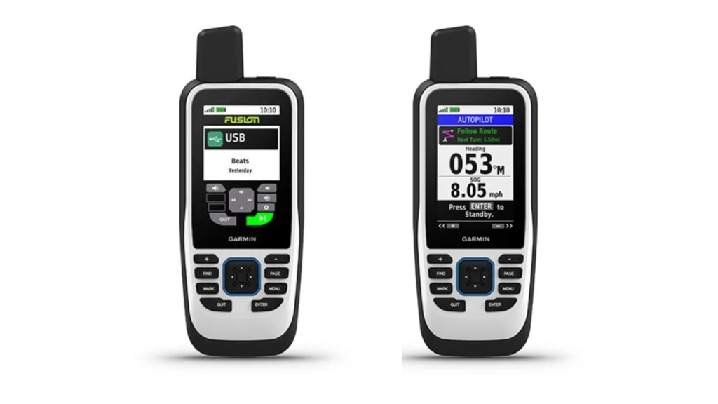
Garmin GPSMAP 86S
The Garmin GPSMAP 86S handheld GPS prioritizes safety and marine navigation for offshore anglers. It adds satellite communication but balances this with higher costs and setup steps. Here’s how it fits into serious fishing trips.
Key Considerations
The Garmin GPSMAP 86S handheld GPS includes an SOS button and inReach satellite texting, critical for remote fishing areas without cell service. Its 3-inch screen resists glare, even in midday sun over open water. Preloaded BlueChart maps mark buoys, marinas, and coastal depths but skip details for smaller lakes or rivers.
Battery life lasts 35 hours in basic mode but drops with active satellite use. The rechargeable battery avoids AA swaps but needs a charging pack for multi-day trips. The device links to fish finders, showing live water temperature and depth—key for tracking fish movements.
Who Is This For
This handheld GPS suits anglers fishing offshore or in isolated areas where safety matters. It works for marking waypoints across vast oceans or tracking drifts near reefs. Boaters value the floating design, though the size feels bulky in pockets. Casual users may find satellite subscriptions and menus overwhelming.
| Pros | Cons |
| SOS and satellite texting for emergencies | Requires costly inReach subscription |
| Streams depth/temp from boat sensors | Preloaded maps lack inland details |
| Floats and survives harsh marine conditions | Bulky for kayak storage |
| Adjustable GPS filter smooths wave data | Steep learning curve for satellite setup |
| Links to autopilots and Fusion stereos | Backlight lacks mid-range brightness |
The Garmin GPSMAP 86S handheld GPS pairs with Garmin’s Explore app for route planning, though the app lacks marine charts. Anglers note the TracBack feature helps retrace routes to hotspots, but map scrolling lags in rough seas.
Satellite messaging requires a clear sky view and patience to activate. Users mention outdated base maps needing paid upgrades for current coastal data. For offshore safety and marine navigation, the Garmin GPSMAP 86S delivers, but costs and complexity may deter casual users.
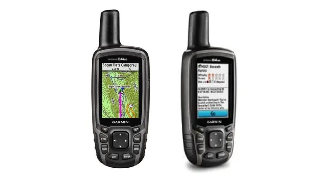
Garmin GPSMAP 64st
The Garmin GPSMAP 64st handheld GPS balances ruggedness with basic navigation tools. Designed for outdoor reliability, it suits anglers and adventurers needing precise tracking without touchscreen dependency. Here’s how it holds up.
Key Considerations
The Garmin GPSMAP 64st handheld GPS includes a 2.6-inch sunlight-readable screen, ideal for bright days on water. Its IPX7 waterproof rating handles rain or splashes, and the device floats if dropped. Preloaded TOPO 100K maps show terrain contours and shorelines, but detailed fishing spots often require adding BlueChart marine maps via microSD card.
Storing 5,000 waypoints helps anglers mark fishing hotspots or boat ramps. The TracBack feature guides retracing routes, useful for navigating back through winding rivers. However, the interface relies on physical buttons, which feel outdated compared to touchscreens. Menus take time to navigate, and the manual lacks clear guidance for setup.
Who Is This For
This handheld GPS suits anglers prioritizing durability over modern features. It works for kayak fishing or shoreline trips where water resistance matters. Hunters and hikers may value its GLONASS support for faster satellite locks in dense forests. Casual users might find the learning curve steep without online tutorials.
| Pros | Cons |
| Durable, waterproof design (IPX7) | Outdated button-based interface |
| Stores 5,000 waypoints for fishing zones | Preloaded maps lack detailed water data |
| Fast GPS + GLONASS satellite locks | Short battery life (8–12 hours actively) |
| Compatible with BlueChart marine maps | Steep setup for custom symbols/waypoints |
| Floats if dropped in water | Requires paid BirdsEye subscription |
The Garmin GPSMAP 64st handheld GPS pairs with smartphones for live location sharing via Garmin Connect. Anglers note the quad-helix antenna maintains signal near cliffs or thick tree cover. However, adding marine charts or custom symbols involves extra costs and patience with Garmin’s BaseCamp software.
Battery life drains quickly with backlight or Bluetooth use. Lithium or rechargeable AA batteries extend runtime but add recurring costs. For anglers needing a tough, no-frills GPS to mark waypoints in remote areas, the Garmin GPSMAP 64st delivers. Yet map upgrades and menu complexity may frustrate tech-focused users.